BOUCLE D'AVERTON PAR LE MERDEREAU (N°59)
Walks and hikes
in Averton
-
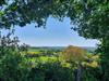
A very pretty trail in the Merdereau valley, in the forest and on the heights of Averton, with some panoramic views and good dirt tracks that make up 73% of the route.
-
From Place de l'Eglise, take Route de Gesvres, then right at the wash-house and right again, past the lagoons and along the stream, over the bridge over the river "du Moulin du Bois ou Ossence" and then right on "le Merdereau". Here the two streams meet. Follow the path up past the springs that once supplied the Château d'Averton with water by gravity. When you reach Monteuzan, turn left behind the house, then left onto the path that leads to La Butte. This is a magnificent vantage point...
From Place de l'Eglise, take Route de Gesvres, then right at the wash-house and right again, past the lagoons and along the stream, over the bridge over the river "du Moulin du Bois ou Ossence" and then right on "le Merdereau". Here the two streams meet. Follow the path up past the springs that once supplied the Château d'Averton with water by gravity. When you reach Monteuzan, turn left behind the house, then left onto the path that leads to La Butte. This is a magnificent vantage point overlooking the forest. Go down the small road on the left and come to a "Thon d'Orthe" bridge at the edge of the forest. Cross the bridge, then go straight on for 50 metres and turn left up a track on the edge of the forest. Continue straight ahead. Note that signs indicate that you can shorten the route by returning directly to Averton (alternative*). Alternatively, continue straight ahead through the forest until you reach the D119 (busy road, take care). Follow this road to the left for 30 metres, then take the track to the right which climbs towards "les Roches Plates", continue straight on and arrive at "Rochalais", cross the small road at the top of the hill near the water tower and continue straight on. Here again, there is a magnificent view of the surrounding hills, with the Sillé forest and the Coëvrons in the distance .... (see map on site). At the end of this path, go down through the "Vieux Champs". When you reach "La Barberie", go down the D255 for 500 metres and at the crossroads, turn left onto the D119 for 20 metres, then right onto "Le Champ des Oiseaux", go up the path and turn right onto the path running alongside the château grounds, of which there is still a wall on the left-hand side of the path. Continue along this path until you come to the gate of the château grounds. Go straight ahead to the wash-house and join the church.
(*) An alternative route through the forest can be taken to return to Averton via the "Chaude Bruyère", bringing the circuit back to 8 km.
- Departure
- Averton
-
-
Documentation
-
- Fiche 59 - Sentier d'Averton par le Merdereau.indd
- 059_boucle_daverton_par_le_merdereau-5314389-1685459229-157
-
- See all reviews